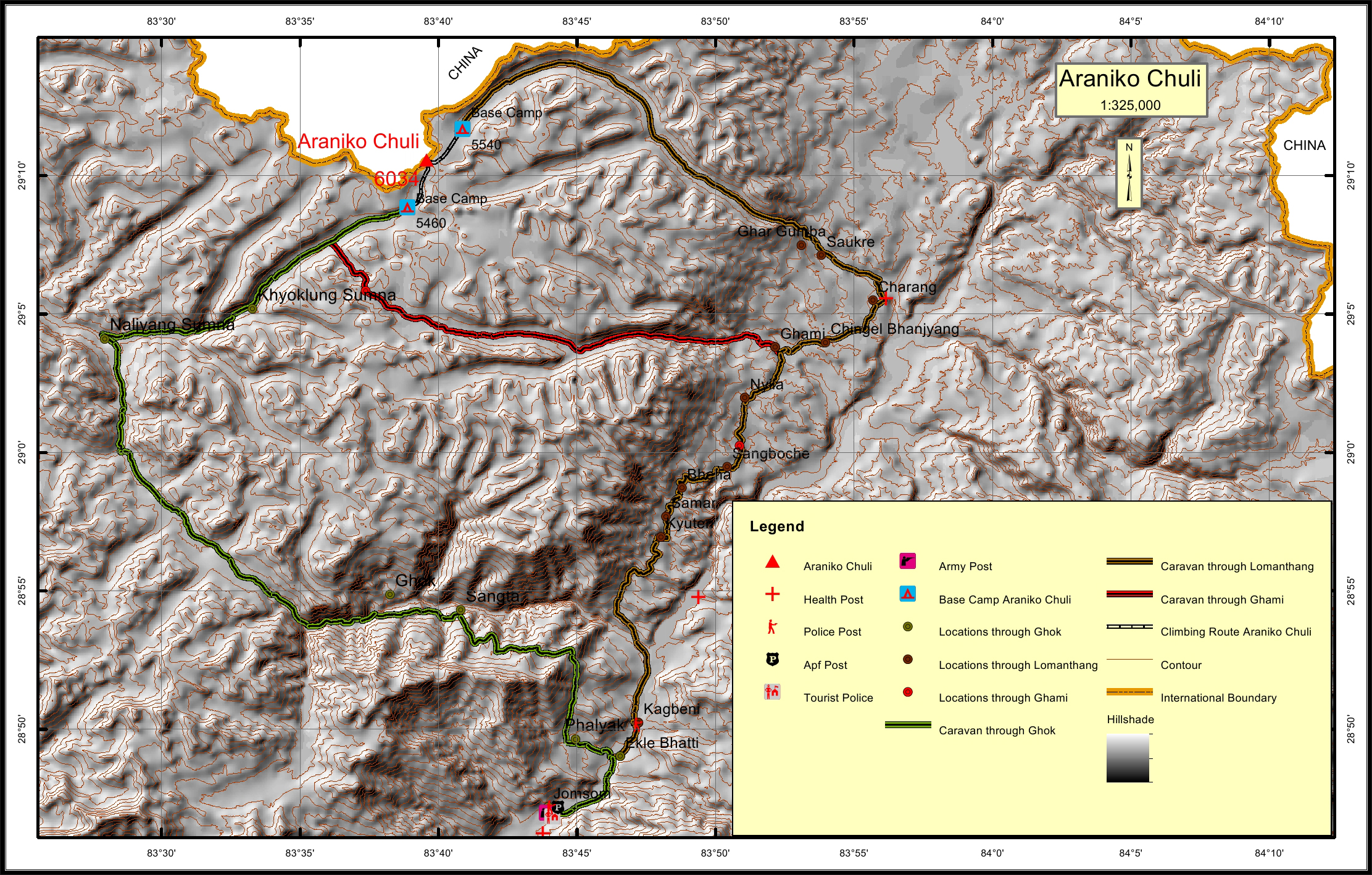
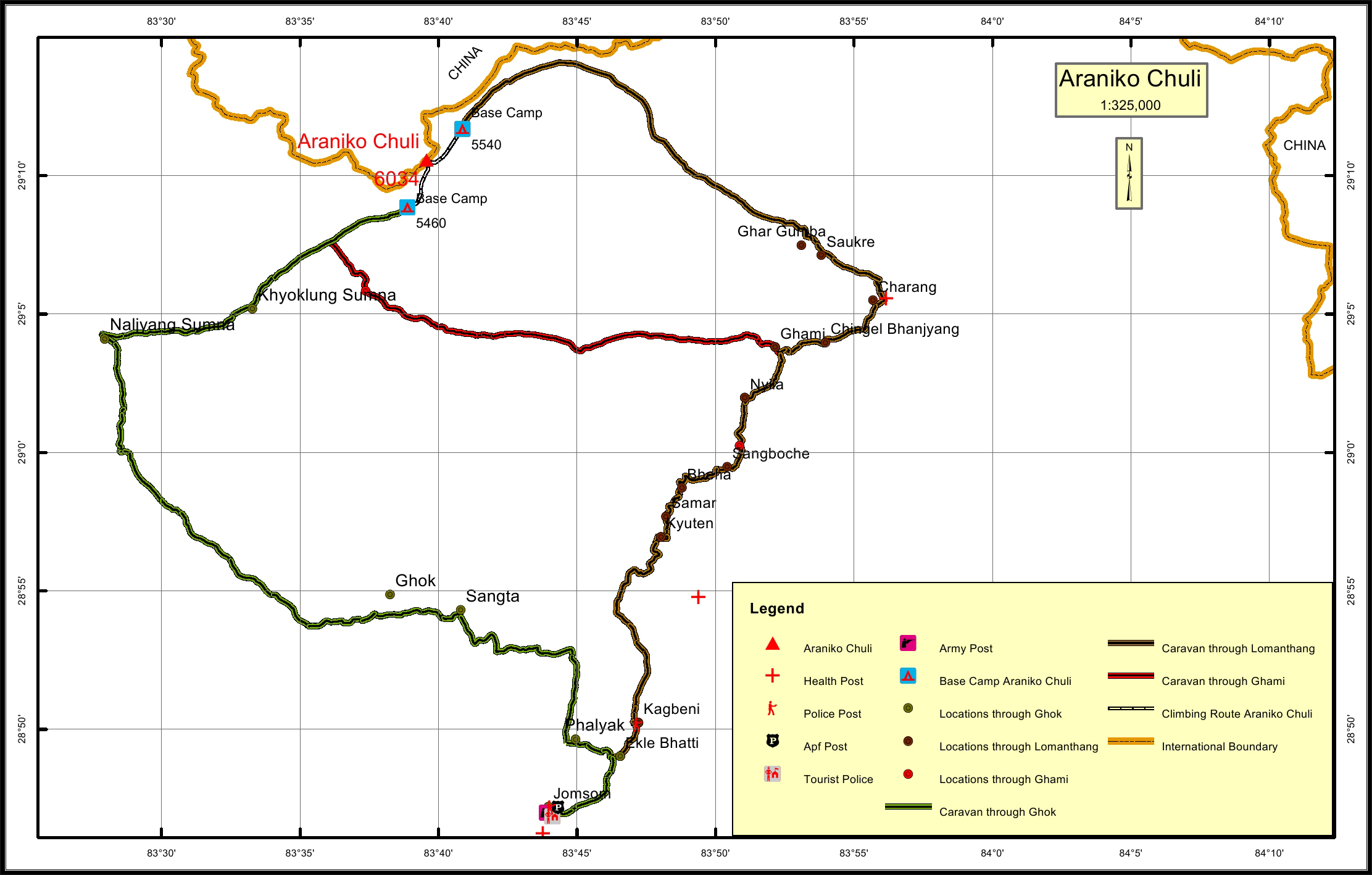
Araniko Chuli Overview

Other Name

Arniko Chuli

Peak ID

ARNK

Status

Opened

Elevation

6039 M / 19796 FT

Latitude

29º 10' 34"

Longitude

83º 39' 34"

History

1st ascent on

10 July, 2002 A.D

1st ascent by

Tamotsu Ohnishi ( Japan ),
Ang Phurba Sherpa ( Nepal ),
Dikki Sherpa ( Nepal ),

Araniko or Aruniko is the name after a famous artist of Nepal who went to Tibet in the later 13th Century to design statues for Buddhist monasteries.

Location

  • Province:

    Gandaki Pradesh
  • Mountain Range:

    Damodar
  • District:

    Dolpa/Mustang/NC
  • Municipality/Rural Municipality:

    Chharka Tongsong/Dalome/NC

Nearest help center

( from the basecamp along
the caravan route )
  • Police post:

    Jomsom 83KM Kagbeni 70.9KM Kagbeni 77.9KM
  • Armed police post

    83KM via Ghok, 80KM via Ghami, 86.5KM via Charang
  • Army post:

    Jomsom 83KM Jomsom 80KM through Ghami, Jomsom 86.5KM through Charang
  • Health centre/post:

    Jomsom 83KM Chhusang 60.7KM Charang 34.3KM
  • Tourist police post:

    Jomsom 83KM Jomsom 80KM 86.5KM
  • Nearest settlement :

    Sangta 57.6KM Ghami 36.1KM Saukre 29.3KM

Royalty Fees

  • Nepalese (NRs):

    fixed Rs. 4000/- in summer, Rs. 2000/- in autumn and Rs. 1,000/- in winter
  • Foreigners (USD):

    $250.00 in summer, $125.00 in autumn and $70.00 in winter

How to get there

  • From Kathmandu:

    By flight to Pokhara and Jomsom or drive to Jomsom
  • Caravan route:

    Jomsom-Ekle Bhatti-Ghok-Naljyang Sumna-BC /Jomosom-Kagbeni-Chhusang-Ghami-Ghami Bhanjyang-BC/ Jomosom-Kagbeni-Chhusang-Ghami-Charang-BC
  • Caravan route
    length:

    83KM through Ghok, 80KM through Ghami, 86.5KM through Charang
  • Climbing route
    length:

    3.6KM through Ghami and Ghok, 3.4KM through Charang
  • Duration:

    18 Days

Maps